Makhtesh Ramon
Makhtesh Ramon is the largest makhtesh in the world, measuring about 40 km in length and 9 km in width, and with a depth of 500 meters. It is a popular place to visit because of its beauty and the many activities it has to offer. However, it is worth planning in advance what you would like to do. Popular destinations include the Makhtesh Visitor Center, visiting the main sites within the canyon by car to view their geological features, hiking in the canyon, either short or long hikes for the desert experience, star gazing at night as there is no light pollution here, rappelling, and jeep trips.
A makhtesh is a unique form of crater found only in the Negev and the Sinai Peninsula that is formed not from a meteoric impact or volcanic eruption, but from erosion. There are five in Israel and this makhtesh is the largest. Makhtesh is a Hebrew word, which is also recognized in the geological world. This makhtesh is called Makhtesh Ramon because of a Roman road within the crater. This same road was used by the Nabateans as part of their Incense Route, but was taken over by the Romans when they annexed their territory.
The best-selling guide for exploring in and around Jerusalem
"In and Around Jerusalem for Everyone - The Best Walks, Hikes and Outdoor Pools"
For FREE, speedy, home, courier service from Pomeranz Booksellers in Jerusalem click here (tel: 02-623 5559) and for Amazon click here. To view outstanding reviews click here.
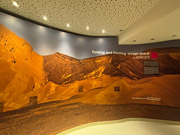
How did this makhtesh form?
A makhtesh is formed on top of a mountain ridge, in this case the Hatira Ridge, and allows you to peer into the inside of the mountain!
Initially, its surface rock was hard sedentary limestone and dolomite (a form of limestone) and underneath this was a softer sandstone that formed in the Cretaceous period, about 100 million years ago (a).
The first stage in the development of this makhtesh was the deposition of sand from the Arabian desert and from the breakdown of granite. This sand will eventually be converted into sandstone. Following this, hundreds of millions of years ago, the Negev was covered by an ocean, the Tethys Ocean, and this led to the deposition of a layer of hard limestone on top of the sandstone.
The next stage in the development of the makhtesh was an upward folding of the earth’s surface because of volcanic and tectonic forces. It is presumed that this led to cracks occurring within the peak of the limestone. The limestone summit was now worn away due to water and wind erosion, exposing the soft sandstone underneath. Because of the differential in height between the uplifted mountain and the Rift Valley, fierce floods washed away this sandstone and deposited it in the Dead Sea via Makhtesh Ramon’s single natural outlet, Wadi Ramon.
Over millions of years, the makhtesh continued to collapse inwards and the makhtesh widened and deepened, exposing ancient rock underneath. This included dark volcanic rock from volcanic eruptions and dykes through penetration of magnum into sedentary rock. If not for the depth of the canyon, these would not be visible on the surface.
The makhtesh is surrounded by cliffs, except at its outlet Wadi Ramon. There are mountains, including Har Ramon (Mt. Ramon) at the southern end, Har Ardon (Mt. Ardon) at the eastern end, and two table mountains along the southern wall. The deepest point of the crater is at Ein Saharonim, which is the only spring in the crater and where water also accumulates from the winter rains.
Places to visit in the makhtesh:
Mitzpe Ramon Visitors Center
A worthwhile first stop is the Makhtesh Ramon Visitors Center. This is situated on the northern rim of Makhtesh Ramon and at the edge of the city of Mitzpe Ramon.
The center covers three topics — the story of the Israeli astronaut Col. Ilan Ramon, the geological formation of the makhtesh, and the flora and fauna of the makhtesh.
Col. Ilan Ramon was an air force pilot who participated in the successful bombing of Iraq’s nuclear reactor near Bagdad and then became Israel’s first astronaut. Unfortunately, he and the six other astronauts perished on their return journey from space when the Space Shuttle Colombia exploded from a malfunction. His story is told through short movies. Ilan Ramon neither lived nor worked in Mitzpe Ramon; the connection is in his name (which was not his original family name). This exhibit is a memorial to his becoming Israel’s first astronaut.
The second section of the Visitors Center describes with large posters and a functioning model the geological formation of the makhtesh. The third section is also informative. It is very easy to go through the makhtesh and conclude that it is devoid of animal life. This is far from the case. Much of the animal life is nocturnal, although not all. The movie is in English, and also with English subtitles.
Directions: Enter “Mitzpe Ramon Visitor Center” into Waze.
Admission:: This is a site of the Israel Nature and Parks Authority (as is the rest of the park). It is open Sunday to Thursday and Saturday 8.00 a.m. to 5.00 p.m., and Friday and holiday eves 8.00 a.m. to 4.00 p.m. Closing is one hour earlier in the winter. Entrance is one hour before closing time. According to their website, admission is by reservation only. Admission is 31 NIS for adults, 18 NIS for children, 26 NIS for students and 16 NIS for Israeli seniors. There is a small gift shop. Restrooms are outside. Their phone number is 08-6588691. This is their website.
Public transport: Enter “Mitzpe Ramon Visitors Center” into Moovit.

Map of Makhtesh Ramon

Movie about Ilan Ramon in the Visitors Center
HaNagariya (“Carpentry Shop”) (labeled minsara on the Hebrew map)
On a slope inside the crater on the makhtesh floor is an accumulation of polygonal pillars. The parking area is just off the main makhtesh road Route 40.
This slope is approached by a wooden walkway. You can return the way you came. It is also possible to step over the rope by the nagariya and hike along the path straight ahead and this leads you back to your car.
This rock began as sedimentary sandstone. However, during later tectonic activity, magna intruded by the rock and strongly heated the sandstone. The sandstone underwent contact metamorphism and the quartz grains recrystallized and fused to form quartzite. Pressure played a role, but heat was the dominant factor. When the rock cooled it formed into thousands of polygonal pillars.


The wooden walkway to the Nagariyah
The Ammonite Wall
When thinking of marine fossils, one usually thinks of small things that need a lot of searching for. This is not the Ammonite Wall. This is a rocky limestone face on the southern wall of the makhtesh that is densely packed with the fossils of ammonites. And they are quite large.
Ammonites were marine mollusks that lived from about 400 million to 65 million years ago in the Tethys Ocean, an ocean that once covered the entire Negev. They had eight arms and an exoskeleton. Their spiral shell was used for buoyancy and movement; chambers in the shell filled with gas or fluid and this enabled them to rise or sink in the water. When they died, they sank to the sea floor and their exoskeleton filled with sediment. This fossilized over time and preserved the shape of the ammonites. They are extinct today but are related to today’s squid, octopus, and cuttlefish.
The Ammonite Wall is accessible from Route 40. An easy trail leads from the parking area.

Many ammonites A pen has been placed on top of one of them to indicate its size.

The trail to the Ammonite Wall
Be’erot Camping Area
This camping area is accessible to all vehicles. It has shaded picnic tables, restrooms, and water and is an excellent place for a lunch stop. This is the only camping areas in the makhtesh that provides services, namely accommodation, full lighting, electrical outlets, drinking fountains, barbeque area, bonfire areas (bring your own firewood), fixed and movable benches and tables, mobile phone charging units, restrooms, showers and a field kitchen. There is camping in one’s own tent. Guests may order a mattress for an additional fee when reserving through the reservation system while supply lasts and with no guarantee. Overnight camping in a large tent with partitions is available for 7–13 campers in each partitioned space. Booking is via winter@npa.org.il

Be;orot camping area provides an array of services
Ein Saharonim and Khan Saharonim
The parking lot for the spring is the trailhead for a number of hikes. They are described on a sign. The Nekorot Horseshoe, for example, is a 3 to 4-hour circular trail with just mild elevations, and is ideal for a family hike. En Saharonim and Khan Saharonim are a short distance from the parking lot.
Khan Saharonim are the ruins of a khan that served as a way-station on the Nabatean Incense Route from the 1st century BCE to the 3rd century CE. It was a square structure (42 x 42 m) with long rooms surrounding a central courtyard.
This route was taken over by the Romans after they annexed the Nabatean Kingdom in 106 CE. The road you see from the khan on the way to Avdat was built in the Roman period, and had milestones. These are stones marking distances approximately 1,500 meter apart.
From the khan it is a short descent to the spring of En Saharonim, and this is where the Nabatean’s camels would have gone to drink. The spring is surrounded by rich vegetation, including a few date palms. Water from the spring is present all year round, although you might have to scrape the soil a bit to reach the superficial aquifer.

Ein Saharonim


Digging for water at Ein Saharonim

Ramon Colors Route
This is a scenic dirt road prepared by the Nature and Parks Authority. It is suitable for all vehicles, and is the main entrance to the eastern part of Makhtesh Ramon. The dirt road was prepared by rehabilitating a former mining and excavation area. Along it can be seen the exposed rocks, colored sands and rehabilitated excavation sites.