The Beit Guvrin-Maresha National Park has been recognized as a UNESCO World Heritage Site and is a popular tourist destination. Importance of this site is that it is a unique example of Hellenistic city that has not been significantly built upon since this period. If you are using your car, you will stop at five designated parking areas and view the places of interest around this area. A more energetic alternative is to hike around the periphery of the park and to walk to each of the sites.
Fourteen sites of interest are described in the brochure. Most guides are selective in what they visit and you will probably wish to do the same. The most interesting sites are therefore marked with an asterisk. Use the map in the brochure to orientate yourself as to your location. If viewing the park by car, stop at parking lots A, B and C and the parking lot for the Bell Caves. lot. If hiking around the periphery, park in Parking Lot A for the duration of your hike.
The must-have guide for exploring in and around Jerusalem
"In and Around Jerusalem for Everyone - The Best Walks, Hikes and Outdoor Pools"
For FREE, speedy, home, courier service from Pomeranz Booksellers in Jerusalem click here (tel: 02-623 5559) and for Amazon click here. To view outstanding reviews click here.
MARESHA AND BEIT GUVRIN
A tour of the ancient city of Maresha is a tour of basements. This is because there are almost no above-ground buildings remaining. Many of the underground structures are well preserved and include cisterns, workshops, columbariums (dovecotes), burial caves, and quarries.
The rock in this area is chalk, which is easy to tunnel through. The chalk is covered by a thin layer of hard limestone called nari. To construct a cave, people made a hole in the nari. Once the soft layer was reached, the chalk was carved out and removed to form a bell-shaped cave. The nari functioned as a firm ceiling. Chalk is not porous and these caves were always dry whatever the weather. The coolness and constant temperature of the caves made them ideal workshops, including for a major industry, the making of olive oil. Caves up to several stories deep can be seen here.
Because of the non-porous nature of the rock in this area, the aquifers are very deep and there are no natural springs. Rainwater was therefore collected from the roofs of the houses and the streets into cisterns. Households often had cisterns beneath their homes as is evident in the Villa. These cisterns were non-porous and required no waterproofing.
Maresha is located on a high hill and is named after the Hebrew word for a head (rosh). It is mentioned in the book of Joshua as a Canaanite city (Joshua 15:44), and was a Jewish Judean city during the First Temple period. When the southern Israelite kingdom was exiled by Nebuchadnezzar II to Babylon in 586 BCE, Edomites living south of the Dead Sea joined with the Babylonians in the destruction of Jerusalem. Because Judah was depopulated, they moved into the area west of the Dead Sea and became the dominant ethnic group. This new Edomite kingdom was called Idumea and Maresha was one of its major cities. The land previously occupied by the Edomites was taken over by the Nabateans. During the Persian period, Phoenicians also moved here from Sidon, possibly for trading purposes.
With the conquest of the country by Alexander the Great in 332 BCE, Maresha, or Marisa as it was called, became a cosmopolitan Hellenistic city, initially part of the Ptolemaic Empire formed by one of Alexander’s generals and then the Seleucid Empire formed by another of his generals. With its population expansion, the city limits of Maresha expanded beyond the fortified tel and onto its lower slopes.
After a long struggle against the Greeks, the Hasmoneans were eventually able to establish control over the country because of a power vacuum due to infighting between Seleucid factions, and John Hyrcanus conquered and lay waste to the city in 112 BCE. He forcibly converted the Edomites to Judaism. This had little to do with evangelical religious zeal and more to do with his efforts to control this part of Judea. Nevertheless, his actions were opposed by the Rabbis. It would lead eventually to an ethnic Edomite taking control over Judea, since the grandfather of Herod the Great was an Idumean leader who had converted to Judaism under the Hasmoneans and had probably lived in Maresha.
In 63 BCE Pompey separated Maresha from the Jewish kingdom and returned it to Idumia. Sixteen years later, Julius Caesar annexed the city back to Judea. The city was totally destroyed by the Parthians in 40 BCE as part of a power struggle between the Hasmonean Antigonus and Herod. The Parthians supported Antigonus while Herod was backed by Rome. Maresha was not rebuilt, and following its destruction, nearby Bet Guvrin gained in importance and became the main city in this area.
Beit Guvrin was captured from the Jews by the Roman general Vespasian during the Great Revolt of 68 CE, and again by the Romans during the Bar Kochba revolt in about 132 CE. On both occasions the Jews were slaughtered. After the Bar Kochba revolt, Rome decided to keep a garrison permanently in this area. Its Jewish population also gradually grew. Beit Guvrin became one of the most important cities in Roman Palestine. It was given the status of a city by the Emperor Septimus Severus in 200 CE and renamed Eleutheropolis. Roman cities were thirsty cities because of their baths and gardens, and spring water was brought here by aqueducts from the Judean Mountains.
During the Byzantine period Beit Guvrin became Christian. The Crusaders built a castle at this site. Prior to the 1947-1948 War of Independence, there was an Arab village here. Kibbutz Bet Guvrin was founded close to the ancient city of Beit Guvrin in May 1949.
It was not until the late 19th and early 20th centuries that archeological excavations uncovered the remains of Maresha and Beit Guvrin, and revealed their rich history.
HIKE AROUND THE PARK:
Time: 3¾ hours. Allow additional time for visiting the amphitheater
Type of walk: Circular
Difficulty: Relatively easy walking on gravel footpaths and some bare rock. There may be a lot of steps to get to the bottom of multistory caves.
Directions and starting point: Enter into Waze "Beit Guvrin" and click on "Parking Beit Guvrin." For both hiking and viewing by car, start at Parking Lot A. (From the entrance of the park, continue straight ahead on the Visitors Path (not the Bell Cave). Ignore the first parking on the left and continue until you come to the first parking lot marked Parking Lot A. There are restrooms here.
Admission: The park is administered by the Israel Nature and Parks Authority. During the summer it is open from Sunday to Thursday 8.00 AM to 5.00 PM, and Friday and eves of holidays 8.00 AM to 4.00 PM. It closes an hour earlier during the winter. Admission is 28 NIS for adults, 14 NIS for children, and 24 NIS for seniors and students. Be sure to obtain a brochure in English. This also contains a map and a description of the different sites. The phone number is 08 681 1020. This is the park’s website.
Public transport: Enter "Beit Guvrin" into Moovit and click on "גן לאומי בית גוברין-מרשה". From Lachish, bus 66 stops at בא׳׳פ לכיש and it is a 20-minute 1-mile walk from there to the park entrance.

The Bell Caves were formerly quarries in the Hellenistic and Islamic periods.
The hike:
On the opposite side of the road to the parking lot are agricultural exhibits. These include an olive press. There is a similar oil press in The Oil Press Cave (#6) and details will be discussed there. A threshing floor and wine press have also been reconstructed. Beyond this, in the direction of the fields, is a display of columns, column bases, pedestals, capitals and cornices from the Hellenistic to late Islamic period and agricultural devices. None are labelled or explained.
-
At the far end of the parking lot, take the walking trail indicated by a sign. There is also a pole with blue bands. The first cave you come to is The Polish Cave (#2) and close to this *The Columbarium Cave (#3). [Sites marked with an * are considered more worthwhile visiting].
The raising of doves was a major industry in the Shfelah in the Hellenistic period and some 85 columbarium caves have been found in Maresha. There are over 2,000 niches in this particular cave. The cave is in the shape of a double cross and there are two openings in the ceiling. Raising doves required little labor as the birds fed themselves. The doves and their eggs were used for food. In an age without refrigeration, a single dove made a convenient food portion. Doves were also used for sacrificial purposes and their droppings could be gathered and used for fertilizer, especially for the olive trees. The Talmud (Bava Kama 79b) forbids using the pigeons of the Idumeans because they were assumed to forage in others’ fields, particularly grain, and were therefore regarded treated as stolen property. This industry came to an end in about the 3rd century BCE.
-
Continue along the footpath in the direction of Parking Lot B, and you will come to the "Bathtub Cave" (#4) and the *Oil Press Cave (#5).
Olive oil production was another important industry in this area in that the climate of the Judean Lowlands was very favorable for the growing of olive trees. This cave would have been a busy one for the 3 months of the harvesting period. This particular olive press from the Hellenistic period is reconstructed. The olives were first crushed in a mill, since the olive pits were also a source of oil. This involved a round basin with a crushing stone that revolved around the basin. The first oil could be dripped from this mush. The mush was then placed in straw baskets and about 10 baskets at a time were pressed by attaching weights to the far end of the beam.
-
Continue on the footpath to *The Villa (#6).
This home is a partially reconstructed 2-storied villa from the Hellenistic period. The walls were plastered in the modern period to prevent the soft chalk walls from weathering. Beneath the home are deep cisterns and a quarry and these can be visited. There are also steps to what would have been a second story.
-
After leaving the villa, you will immediately come to a fork. The left-hand fork leads to the top of the tel, although it may be blocked off. If this is the case, go to Parking Lot B and take the path from there to the top of the tel, going around the white gate and following the sign to Tel Maresha. It is worth visiting for the view.
To orientate you - Route 35 is to your north. To the east are the Judean Mountains, and to the west the coastal plain. In this direction, you can make out the tall buildings of Kiryat Gat, which is also in the Sh’felah.
-
Go back to the parking lot from the tel and continue on the gravel path marked by a sign Continuation of Route. You will soon come to the *Maze Cave (#7).
The Maze Cave was constructed in the Hellenistic period and once had dwellings above it. Within the interconnected maze are cisterns, a quarry, columbarium, bathing chamber and olive press. In Hellenistic Maresha, the rooms would not have been so interconnected.
-
Go to the path at the far end of this area, which is signposted to The Sidonian Caves. This path will lead you to the main park road. There is a sign Parking Lot C, Sidonian Caves and Visitor Service Center.
There are restrooms, plenty of picnic tables and a gift shop in this area that sells hot and cold drinks and snacks.
-
A path at the far end of the courtyard leads to the left and is signposted to the burial cave *Appolophanes Cave (#8). Appolophanes was a leader of the Sidonian community in Maresha.
The burial caves consist of a central hall with benches and above these are niches. The deceased was laid in the niche and the bones later collected and placed together with other members of the family in a special depository. This custom of bone collection was also part of the Jewish tradition. Burial in niches continued until the end of the Hellenistic and early Roman periods.
The niche facing you as you enter was carved in the form of a Greek temple. All the paintings are reconstructions from drawings after the tombs were plundered in the early 1900s. Other images painted in the tomb include a war elephant, giraffe, wild boar, rhinoceros, crocodile, hippopotamus and mythical creatures. such as a griffon and bearded lion. It is likely that the artist had never seen many of these animals.
-
Continue on the footpath past the Sidonian cave to the remains of St Anne's church (#10). The path is more uneven but is relatively easy.
This large church dedicated to the mother of Jesus’ mother was built during the Byzantine period and restored during the Crusader period, although on a smaller scale. The large apse (semicircular hall) is very apparent.
-
Continue walking on the footpath until you come to an unpaved vehicular road. Cross this and go through the grey gate. The footpath will lead you to the *Bell Caves (#12). There are restrooms here.
-
From the restroom area, continue on the path ahead. Take the first left turning to the northern quarries.
These caves located on the outskirts of the ancient city of Beit Guvrin were a series of quarries, and are worth visiting because of their beauty. A shaft was first cut through the harder rock (nari) to a depth of about 3 meters to reach the soft chalk layer beneath. Blocks of rock were then removed with ropes through the shaft. These quarries were begun in the Byzantine period and reached their peak use during the early Islamic period. The chalk rocks were used in building construction and for making lime. In the Islamic period they were used to construct building in Ramla.
-
After visiting the Bell Caves, you can in theory walk along the main park road to the Roman amphitheater on the other side of route 35. However, you will be getting further from your car. It is suggested, therefore, to return to Parking Lot A and to go to the amphitheater by car along Route 35. The walk back to your car has no signs, so use the instructions here together with the map in the brochure.
-
Walk back along the footpath which you came along to the gate. Turn right on this vehicular road. This will bring you to a T-junction with the main circular road of the park. Turn left. Continue along this road until the first intersection on your right. Turn along this paved road which is blocked to traffic. This will bring you again to the main circular road of the park at a T-junction. Turn right and this will lead you directly to Parking Lot A and your car after a short distance.

This is the Sidonian burial cave #8 by Parking Lot C. The tomb was the family tomb of a leader of the Sidonian community.

The olive press in the Oil Press Cave.

An olive press in the Agricultural installation complex by Parking Lot A.
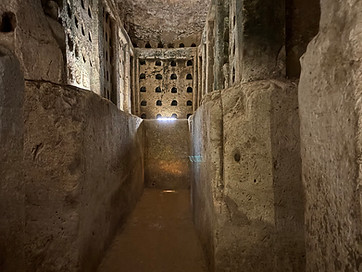
Inside the Columbarium Cave
THE ROMAN AMPHITHEATER AND CRUSADER FORTRESS IN BEIT GUVRIN
A visit to the Roman Amphitheater and Crusader Fortress on the other side of Route 35 is well worthwhile. The Roman amphitheater is particularly impressive. It is only a short distance from Tel Maresha, but because of the way traffic is directed, you will need to go around the park to get there. You can put in “Beit Guvrin Amphitheater “into Waze.
There is a parking lot on the left side of the turning from Route 35. The gate into this section of the national park is either controlled by an attendant or left unlocked until closing time even if no attendant is present. However, mention that you will be visiting the amphitheater when you purchase your ticket to be sure that it will be open.
The Tenth Legion was stationed in Jerusalem and the Sixth Legion was housed here. Roman troops enjoyed being entertained by blood sports so as to be ready for combat. A Roman amphitheater like this is rare in the Middle East, as distinct from theaters, which were primarily for performances and were a standard feature of a Roman city, and hippodromes, which were used for chariot racing. This amphitheater would have been used for gladiatorial contests, fighting hungry wild animals, military parades, and public functions. Those participating in combat would have included Jewish prisoners in what was usually a death sentence. The amphitheater could seat some 3,500 spectators.
There are vaulted tunnels underneath the arena, and the gladiators and animals entered the arena from two separate openings. The original Latin word arena meant “sand”; it became specialized to mean “the sand of the amphitheater”; then it was applied to the scene of the contest, though not to the physical structure. The sand absorbed the copious blood that would have flowed. Blood sports were made illegal by the Church in the Byzantine period and most amphitheaters were abandoned. This one may have been used as a market in the Muslim period.
Follow the signs through the tunnels underneath the arena. After leaving the amphitheater, you can either exit the park or continue on the left towards the Crusader Fortress.
The Crusader church and inner Crusader Fortress were built over the ruins of a large Roman bathhouse, the remains of which can be seen. One of the apses of the Crusader church was converted in the Mamluke period into a mosque.
The inner fortress was built as an independent structure that could be defended if the outside walls were breached. To climb up to the top of the inner fortress for a 360-degree view walk up the stairs in the passageway adjacent to the mosque.
On the other side of the road are the ruins of the Arab village of Bayt Jibrin. Beyond this is Maresha. Behind you is Kibbutz Beit Guvrin, which was established in 1949 after the War of Independence by former Palmach members and youth groups from Turkey and Romania. Beneath you are the ruins of the Roman bathhouse.


The impressive amphitheater at Beit Guvrin.